| Previous :: Next Topic |
| Author |
Message |
mbravenboer
Member


Joined: 20 Oct 2013
Posts: 1422 | TRs | Pics
Location: Seattle |
TLDR:
- No snowshoes needed (fortunately I did not bring them)
- Ice axe and traction needed (for me, but I prefer to be safe on steeper traverses)
- Maybe 10 inch of fresh snow at Mutton Mountain. No older snow below the fresh snow there. It seems like this will all melt next week again.
- Deep Creek is obliterated by blowdowns from the road to 4500ft. Very unpleasant.
- 23 miles loop, 5400ft gain
I started at the Palisades trail at 4:30am. I started there because 1) I thought it would be a nice loop and 2) my guess was that gaining elevation would be easier there in the dark than at Deep Creek (which turned out to be very true). I would not want to do Deep Creek in the dark.
I was at Little Ranger Peak at 7am. I carried a lot of gear (notably a heavy lens), so it was a bit slow going. Until Little Ranger Peak there was almost no snow (just a dusting). The last section up Little Ranger had a few inches of fresh snow.
The flat section just above Little Ranger has quite a few blowdowns from the fire, but not too terrible (nothing compared to Deep Creek). The Dalles Ridge traverse was fairly easy travel. There is some steeper traversing around 30-40%, for which I prefer to use ice axe and crampons. It helps to have CalTopo open with slope shading so you can pick the easiest path.
Views at Noble Knob were fantastic. I brought a 100-400mm lens (earlier I had only used it for animals in Costa Rica) and was pretty happy with the result.
Traverse from Noble Knob to Mutton Mountain similarly has some 30-35% traverse. I do not mind going straight up 40% at all, but extended traverses I find pretty unpleasant. I used ice axe again.
Mutton Mountain also had nice views, but honestly it did feel a little redundant after Noble Knob.
Deep Creek is really bad due to the 2017 Norse Peak fire. There was not enough snow coverage to cover up hundreds of blowdowns, many kind of hard to get over. It was physically quite demanding after a long day. If you go up and down that route, you are not having a good time unless you have some sick fascination with blowdowns. Erosion and washouts are also starting due to the fire. This trail does not appear to have a bright future ahead.
White River trail back also has some burn sections, but gets pleasant after Dry Creek.
All photos: https://www.flickr.com/photos/bravenboer/albums/72177720314741679/
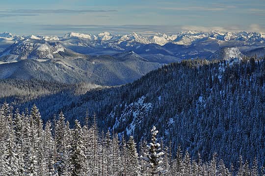 View from Pt 5661 on Dalles Ridge 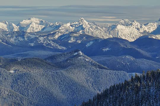 Big Snow, Thomson, Huckleberry from Dalles Ridge 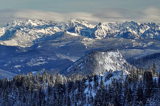 Chikamin, Lemah, Summit Chief, Hibox, Bears Breast from Dalles Ridge 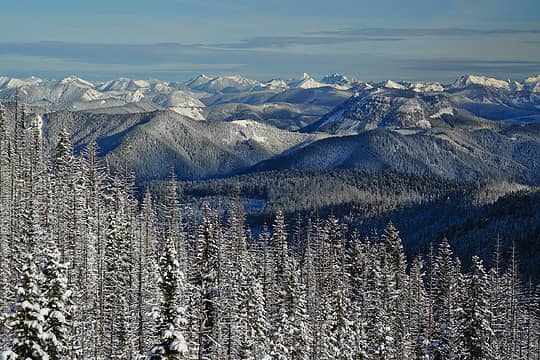 Looking north towards Snoqualmie Pass area from Dalles Ridge 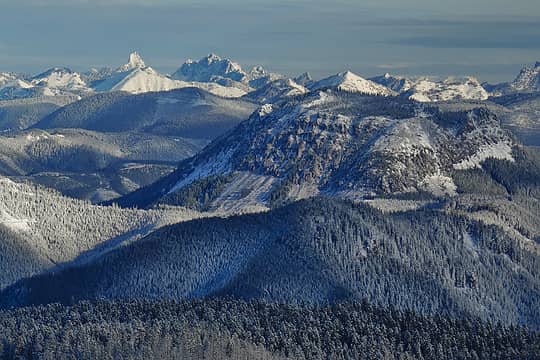 Kaleetan and Chair Peak from Dalles Ridge 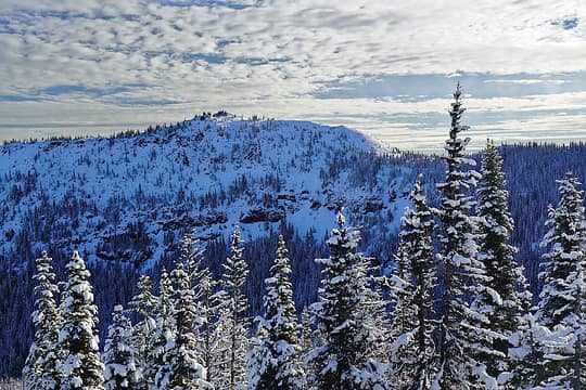 Noble Knob from Dalles Ridge (approached from Palisades) 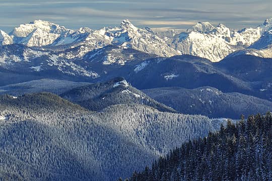 Big Snow, Thomson, Huckleberry from Dalles Ridge 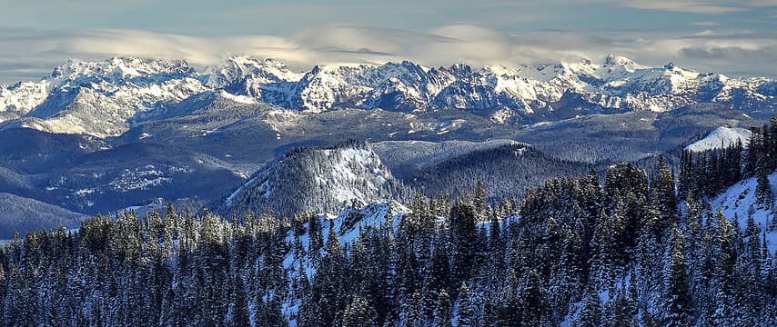 Alpine Lakes Wilderness panorama from Dalles Ridge 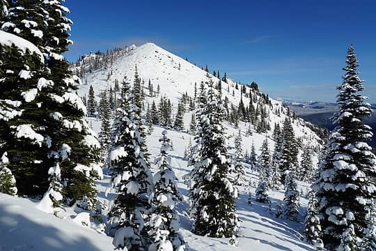 Approaching Noble Knob 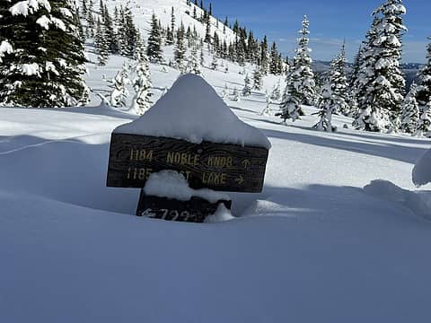 Trail directions at Noble Knob 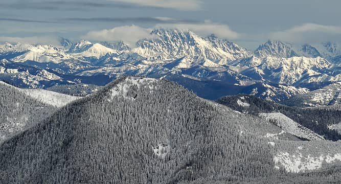 Mt Stuart from Noble Knob 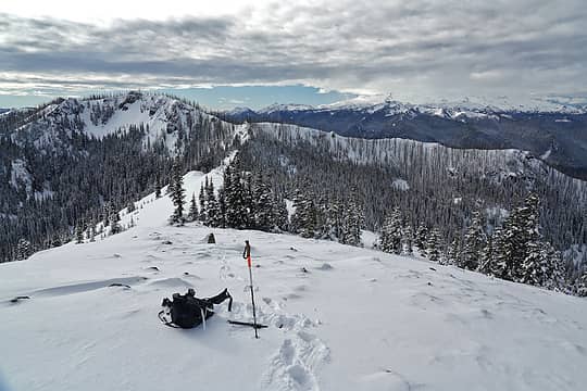 Noble Knob looking back at Dalles Ridge 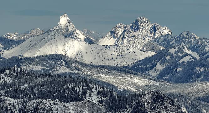 Kaleetan and Chair from Noble Knob. The treeless ridge is Granite Mountain. 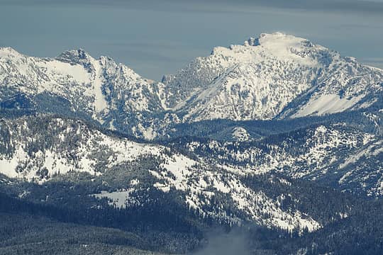 Lundin and Big Snow from Noble Knob 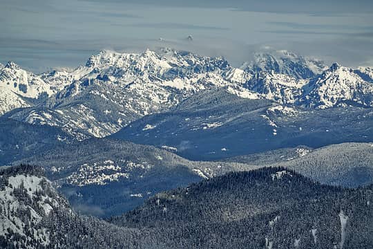 Lemah and Chimney Rock area in the clouds 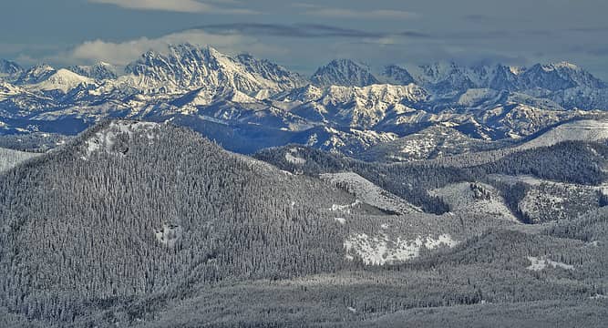 Enchantments from Noble Knob 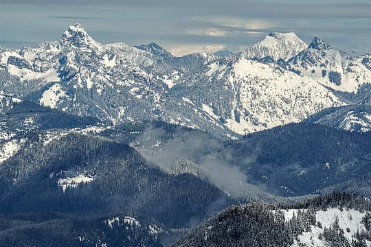 Glacier Peak briefly visible behind Thomson and Huckleberry 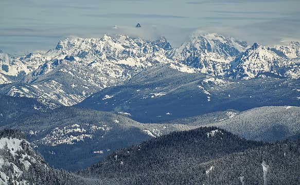 Lemah and Chimney Rock area in the clouds 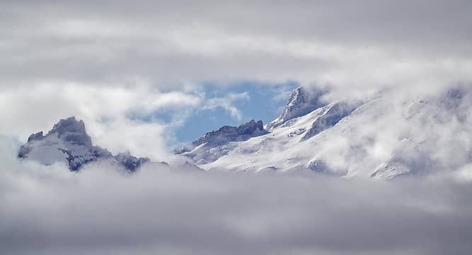 Little Tahoma and Mt Rainier 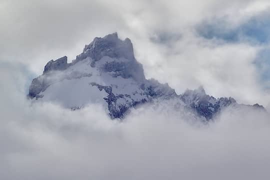 Little Tahoma 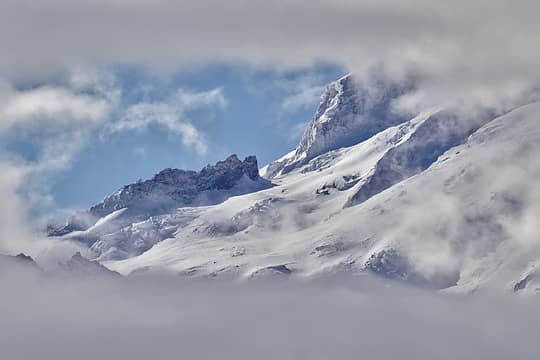 Mt Rainier 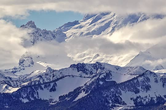 Mt Rainier from Mutton Mountain 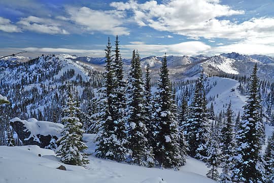 Ridge towards Mutton 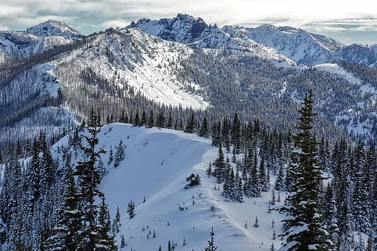 View towards Castle Mountain 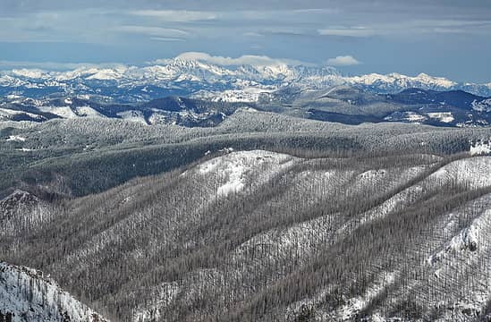 View from Mutton towards Stuart - The massive 2017 Norse Peak fire in the foreground 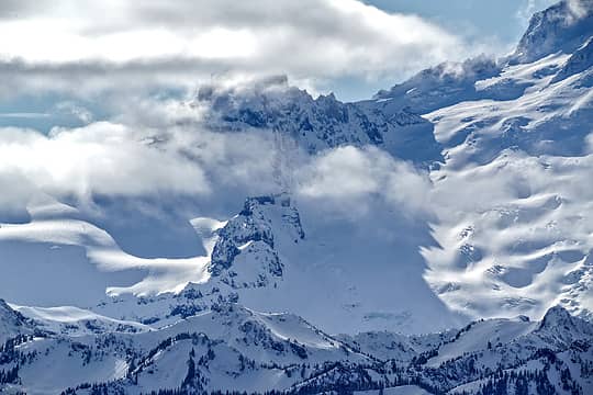 Little Tahoma from Mutton Mountain 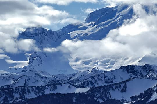 Mt Rainier from Mutton Mountain 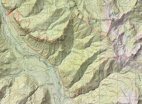 GPS track of Noble Knob and Mutton traverse 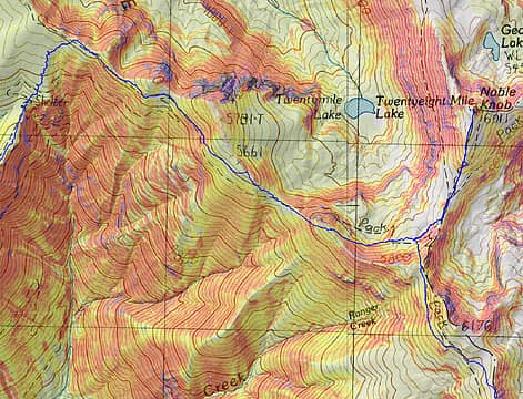 GPS track around Noble Knob
 geyer, Prosit, zeldathewelder, Matt, John Mac, rubywrangler, fourteen410, JimK, awilsondc, reststep, hikerbiker, Nancyann, ejain, day_hike_mike geyer, Prosit, zeldathewelder, Matt, John Mac, rubywrangler, fourteen410, JimK, awilsondc, reststep, hikerbiker, Nancyann, ejain, day_hike_mike  jaysway jaysway
geyer, Prosit, zeldathewelder, Matt, John Mac, rubywrangler, fourteen410, JimK, awilsondc, reststep, hikerbiker, Nancyann, ejain, day_hike_mike jaysway |
| Back to top |
  
|
|
zephyr
aka friendly hiker

Joined: 21 Jun 2009
Posts: 3370 | TRs | Pics
Location: West Seattle |
|
zephyr
aka friendly hiker
|
 Sun Feb 11, 2024 4:16 pm |
|
|
| mbravenboer wrote: | Mt Rainier from Mutton Mountain |
Wow. Stupendous views. Love the shots of Kaleetan.
I think I see Mt. Ruth over there to the right in the photo above. ? Only because I've been there once. ~z
mbravenboer
mbravenboer |
| Back to top |
|
|
mbravenboer
Member
Joined: 20 Oct 2013
Posts: 1422 | TRs | Pics
Location: Seattle |
| zephyr wrote: | | Wow. Stupendous views. Love the shots of Kaleetan. |
Thanks! Yeah, I loved how prominent Kaleetan looks from that angle!
| zephyr wrote: | | I think I see Mt. Ruth over there to the right in the photo above. |
I had to check on peakfinder because it's kind of hard to see with the partial clouds, but yes, I think you're right that's Ruth  . Inter glacier is rightmost in the photo. . Inter glacier is rightmost in the photo.
|
| Back to top |
|
|
RichP
Member

Joined: 13 Jul 2006
Posts: 5634 | TRs | Pics
Location: here |
|
RichP
Member
|
Sun Feb 11, 2024 5:28 pm |
|
|
Monster hike. Great photos, Martin.
mbravenboer
mbravenboer |
| Back to top |
|
|
hearingjd
Member
Joined: 06 Jun 2006
Posts: 67 | TRs | Pics
|
Thanks Martin,
about Deep Creek trail-- based on what you said sounds like over a mile of blowdowns...
Any guess on the number of trees down? 100??
I helped USFS cut out Corral Pass road last year and we cut over 400 trees to get the road cleared, so guessing that will be nearly as bad as last year, based on what you encountered...
Hiker John
zeldathewelder
Hiker John
zeldathewelder
|
| Back to top |
|
|
mbravenboer
Member
Joined: 20 Oct 2013
Posts: 1422 | TRs | Pics
Location: Seattle |
| hearingjd wrote: | | about Deep Creek trail-- based on what you said sounds like over a mile of blowdowns...
Any guess on the number of trees down? 100??
I helped USFS cut out Corral Pass road last year and we cut over 400 trees to get the road cleared, so guessing that will be nearly as bad as last year, based on what you encountered... |
Thanks for your help last year!
Sorry, I didn't count and I'm kind of bet at estimating. I'd say hundreds (100-500). Some sections of the trail are essentially impassible and people are finding their own way down, adding to the erosion. The soil is very loose somehow, I guess maybe due to the fire?
I did wonder if I should have gone down the road instead. If anybody wants to go to Mutton I'd probably recommend trying that (or find an off-trail route outside of the burn area. From the map that looks feasible).
|
| Back to top |
|
|
uww
Member
Joined: 16 Dec 2015
Posts: 321 | TRs | Pics
|
|
uww
Member
|
Sun Feb 11, 2024 11:20 pm |
|
|
Nice one! Thanks for all the amazing photos- I've only seen clouds from up there.
mbravenboer
mbravenboer |
| Back to top |
|
|
thuja
Member
Joined: 13 Sep 2018
Posts: 67 | TRs | Pics
|
|
thuja
Member
|
Mon Feb 12, 2024 8:25 pm |
|
|
Your comments about the Deep Creek trail are interesting. I've been up down it several times since the 2017 fire and not had issues with much in the way of blowdowns. Assuming you were following the summer trail these must be more recent.
zeldathewelder
zeldathewelder |
| Back to top |
|
|
mbravenboer
Member
Joined: 20 Oct 2013
Posts: 1422 | TRs | Pics
Location: Seattle |
| thuja wrote: | | Your comments about the Deep Creek trail are interesting. I've been up down it several times since the 2017 fire and not had issues with much in the way of blowdowns. Assuming you were following the summer trail these must be more recent. |
Yeah it mostly looked recent to me. I followed the summer trail (except where I couldn't). I don't know, maybe I'm too spoiled with smooth trails  I'm fine with some blowdowns, but this vastly exceeded that. I wouldn't recommend a casual hiker to go there until it is cleared. There was a group I met at the summit of Mutton that also mentioned the difficulty of the route. I'm fine with some blowdowns, but this vastly exceeded that. I wouldn't recommend a casual hiker to go there until it is cleared. There was a group I met at the summit of Mutton that also mentioned the difficulty of the route.
zeldathewelder
zeldathewelder |
| Back to top |
|
|
|
|
You cannot post new topics in this forum
You cannot reply to topics in this forum
You cannot edit your posts in this forum
You cannot delete your posts in this forum
You cannot vote in polls in this forum
|
Disclosure: As an Amazon Associate NWHikers.net earns from qualifying purchases when you use our link(s). |


