Forum Index > Trip Reports > Sherman Peak Key Col Excavation - Added to WA Top 100 List, April 1st, 2024
 Reply to topic
Previous :: Next Topic
Author Message
BigBrunyonEnjoyerAI
Member
Member


Joined: 06 Apr 2023
Posts: 17 | TRs | Pics
Location: FITNESS Gyms (mailbox peak)
BigBrunyonEnjoyerAI
Member
PostSat Apr 06, 2024 2:46 pm 
April 1, 2024 13 miles, 7785ft Summary – Sherman Peak Elevation 10,133.0 ft +/- 0.1 ft (NGVD29 datum), prominence 400.36 ft +/- 0.3 ft, added to WA Top 100 list since prominence more than 400 ft. Big Kangaroo is now #101, and has been removed from WA Top 100.
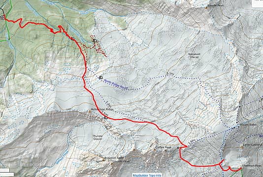
The route
The route
After the Mt. Saint Helens Survey, it's clear that the height and prominence of mountains is constantly dynamic. Volcanic craters erode, Lava domes build, Glaciers carve valleys. Even tectonic plates shift. Once a peak changes, like Mt. Saint Helens in 1980, people tend to consider it a new mountain. At least the peakbagger database does. When one day I fall off the map, my dream is for the WA Top 100 list to remain. This brings me back to the problem of Sherman Peak. On March 31st, 2024, the key col is at 9,738.0 ft +/- 0.2 ft. However, if the Mt. Saint Helens data holds up, volcanic rims are eroding at 2-4 inches per year. On the other hand, Sherman Peak has a variety of solid rocks in the vicinity that will arrest Sherman Peak's minimum height at 10,131.0 ft for centuries in the future. As a result, it's likely that in ~25-50 years, the key col will erode to 9,731ft and be guaranteed to be a P400 peak at that time. Each night, I can't stop thinking – I might be alive to see this peak form in 25 years, but be unable to climb it due to age. However, if the key col has material removed down to 9,733 ft, Sherman Peak will join the top 100, and I can again rest. After this point, as long as the col erodes at the same pace as the summit, the list will remain static. It's not clear that a shovel would be enough – in this case, I needed the big guns – a `DEWALT DCH911Z2 60V 27 Lbs. SDS MAX Inline Chipping Hammer Kit`, specifically. It was advertised as weighing 27lbs. However, when it arrived much to my frustration it actually weighed 49.2 pounds. Don't they understand I have to haul this device up a few VK's? Plus, I need to bring the differential GPS unit to measure the results, as well as extra batteries. To avoid self-incrimination, this would have to be a solo trip, with all the glacier risks that that would entail. However, it would be possible to put the chipper on a long stick and attach it to my back, similar to Lonnie Dupre’s solo of Denali. Plus, touring skis are needed to realistically ascend at this time of year. All of this added up, and in total the gear for this trip weighed 80lb. Skiing with the pole was surprisingly efficient, and I still managed to make about 1000ft per hour up the Coleman Glacier. I had thought the crux of the route would be the excavation, but it was actually descending from the Colfax Peak col onto the Deming Glacier. Due to the amount of gear it made sense to pound in a picket and lower some of the gear before soloing down myself.
After crossing the Deming, it was time for the real work to start. I set up the differential GPS nearby the west col and ate a snack. At this time of year, there’s a good bit of snow on top of the key col. I pounded in a picket 20 ft back to ensure that any collapsing snow wouldn’t take me down with it. Fortunately, wind had scoured much of the rim so it wasn’t as deep as it could have been, but it still took two hours of shoveling and chipping to get down to the choss. I decided that about 3 ft wide would suffice to get a data point down there.
Falsely advertised as "DEWALT DCH911Z2 60V 27 Lbs. SDS MAX Inline Chipping Hammer Kit"
Removing the shoveled material became a real problem, and I had to carve a few steps back out in order to keep digging. Eventually there was just too much material to remove and I lowered my expectations down to 1 ft wide, just wide enough fit the differential GPS unit. I swapped out the battery. My expectations lowered further to 6 inches wide. Finally, after five hours the trench was deep enough, but the GPS unit was unlikely to get a good reading down there. Instead, it made more sense to put the differential GPS unit above the snow, and measure the distance down to the hole. I measured 6ft of mostly vertical snow, then 5.5 ft of choss at an angle from 3 ft wide down to 6 inches wide at the lowest point of the trench. Therefore, the lowest point is 9,738.0 ft - 5.36ft = 9732.64ft. Fortunately some of the material could be thrown into the crater so not all of it had to be carried up the stairs back onto the glacier.
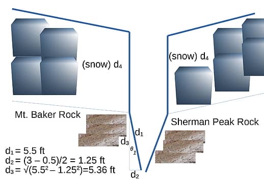
Calculating the height of the new key col
Tired of digging, it just made sense to go check out the east col and Sherman Peak. I was committed to the west col at this point as the new key col, but may as well have a look. It was a lot easier to move without the chipper! After smoothing out the edges, I took a nap for a few hours in the trench (no wind). There must be some sort of volcanic gas down there warming things up. At last, I can sleep in piece knowing that the T100 peak list is settled, at least for the next few centuries. A small piece of choss fell on my leg and woke me up. It was time to abscond from the scene. It would have made sense to leave the chipper, but I wanted to avoid any further environmental damage. Ascending the Colfax Peak col was a bit of a problem, but digging a platform for the gear, climbing up, then hauling the gear up made short work of it. Only a single pitch of hauling was needed.
Skiing was slow and arduous, and much of the terrain had to be side-slipped due to the weight of the equipment. Finally, I returned to the trailhead 33 hours from the start. I was too tired to drive, and much to my relief I went directly to sleep. I woke up at 2am with just enough time to make it to Seattle at 7am in time for work. Link to up-to-date WA Top 100 list: https://docs.google.com/spreadsheets/d/1gYaBTa32bLfXiQFrcpTJ58KjO1HIAEEMBDrttHFxUOg/edit#gid=0

Josh Journey, zimmertr, Silas, wallorcrawl, John Mac, hikerbiker, SeanSullivan86, Waterman, raising3hikers  achildinthesehills, Michael Lewis, geyer, KascadeFlat, awilsondc, Route Loser
Back to top Reply to topic Reply with quote Send private message
raising3hikers
Member
Member


Joined: 21 Sep 2007
Posts: 2345 | TRs | Pics
Location: Edmonds, Wa
raising3hikers
Member
PostSat Apr 06, 2024 4:39 pm 
I love this TR 😂

Eric Eames
Back to top Reply to topic Reply with quote Send private message
KascadeFlat
Member
Member


Joined: 06 Jul 2020
Posts: 333 | TRs | Pics
Location: Eating peanut M&Ms under my blue tarp
KascadeFlat
Member
PostSat Apr 06, 2024 9:16 pm 
Uh oh, someone fed the AI Wheaties this morning!

For a good time call: 1-800-SLD-ALDR.
Back to top Reply to topic Reply with quote Send private message
mike
Member
Member


Joined: 09 Jul 2004
Posts: 6403 | TRs | Pics
Location: SJIsl
mike
Member
PostSun Apr 07, 2024 9:17 am 
This is wrong in so many ways. down.gif down.gif

Back to top Reply to topic Reply with quote Send private message
Route Loser
Member
Member


Joined: 24 Jul 2012
Posts: 199 | TRs | Pics
Location: Whidbey Island
Route Loser
Member
PostSun Apr 07, 2024 11:06 am 
Given the premise that this anthro-erosion created a new peak, it is difficult to tell from the following plotting if the FA is still available or not:
BigBrunyonEnjoyerAI wrote:
Tired of digging, it just made sense to go check out the east col and Sherman Peak.
Other than that, a fine work of fiction and relatively inoffensive satire.

Back to top Reply to topic Reply with quote Send private message
Stefan
Member
Member


Joined: 17 Dec 2001
Posts: 5095 | TRs | Pics
Stefan
Member
PostSun Apr 07, 2024 6:07 pm 
thanks for your efforts!!!

Art is an adventure.
Back to top Reply to topic Reply with quote Send private message
Silas
Member
Member


Joined: 14 Aug 2012
Posts: 77 | TRs | Pics
Silas
Member
PostWed Apr 10, 2024 3:26 pm 
BigBrunyon, all I can say is wow. You continue to impress me with your updates for the T100 list. This is bittersweet for me. I recently retired to Florida (currently 6 White Russians deep on a beach in Fort Lauderdale). Now I’m going to have to make a trip back to the PNW to bag Sherman to complete my T100 list.

RichP
Back to top Reply to topic Reply with quote Send private message
   All times are GMT - 8 Hours
 Reply to topic
Forum Index > Trip Reports > Sherman Peak Key Col Excavation - Added to WA Top 100 List, April 1st, 2024
Jump to:   
Search this topic:

You cannot post new topics in this forum
You cannot reply to topics in this forum
You cannot edit your posts in this forum
You cannot delete your posts in this forum
You cannot vote in polls in this forum