| Previous :: Next Topic |
| Author |
Message |
Tom
Admin

Joined: 15 Dec 2001
Posts: 17865 | TRs | Pics
|
|
Tom
Admin
|
 Wed Nov 15, 2023 6:54 pm |
|
|
Seems as if wawild is also advocating for a NEPA process carried out by the USFS as soon as practicable to permanently prohibit helicopter landings not just at Copper Lake and other USFS lands in the South Fork Stillaguamish and Sultan Watersheds but throughout the entire Mt. Baker Snoqualmie National Forest.
I'm not familiar with how the NEPA process works, but interesting how how they jump to the foregone conclusion of the end result, seems as if NEPA is more a means to an end. While we're at it, how about a NEPA analysis on every single FS road to a trailhead so we can just gate roads as far back as possible? I bet that would have more impact on protecting the watersheds than banning a few helicopter landings.
 runup runup
runup |
| Back to top |
  
|
|
altasnob
Member

Joined: 29 Aug 2007
Posts: 1437 | TRs | Pics
Location: Tacoma |
|
altasnob
Member
|
Wed Nov 15, 2023 8:48 pm |
|
|
I believe their argument is that the USFS issued the commercial heli permit without going through the NEPA process (contending that allowing helis to land at Copper Lake is significant enough federal action that NEPA is required). The current roads in the USFS have already gone through the NEPA process.
|
| Back to top |
|
|
Anne Elk
BrontosaurusTheorist

Joined: 07 Sep 2018
Posts: 2442 | TRs | Pics
Location: Seattle |
|
Anne Elk
BrontosaurusTheorist
|
Wed Nov 15, 2023 9:47 pm |
|
|
| Tom wrote: | | Yes, let's refer to them as tourons. Never liked that term personally. Smacks of arrogance. |
I've never encountered the term previously except in NWH threads. It seems a useful word to encapsulate a range of naive/thoughtless/careless/annoying behaviors of the recreating masses. Is it arrogant? Perhaps. I don't think I am, although I'll cop to being among the cranky cognoscenti of the back country; the condition somewhat aggravated by a seasonally premature bout of cabin fever thanks to a medical situation which hopefully, is over.
It might be getting ahead of the situation, but I can envision this kind of thing (helo-tourism) getting out of hand in a relatively short time. The crash in the lake is almost beside the point, IMO. These "occasional" junkets to Copper Lake (and who knows where else) is the "camel's nose in the tent".
The FAA Is Enabling Helicopters to Ruin the Outdoors
| Quote: | | If there is no credible threat of a mandatory limit, tour operators have zero incentive to voluntarily impose one, says PEER general counsel Paula Dinerstein. |
"There are yahoos out there. Its why we cant have nice things." - Tom Mahood
kiliki, Chief Joseph
"There are yahoos out there. Its why we cant have nice things." - Tom Mahood
kiliki, Chief Joseph
|
| Back to top |
|
|
Slugman
Its a Slugfest!

Joined: 27 Mar 2003
Posts: 16874 | TRs | Pics
|
|
Slugman
Its a Slugfest!
|
Wed Nov 15, 2023 10:19 pm |
|
|
No camels in my watershed please. Nose end or the other end. TIA.
RumiDude
RumiDude |
| Back to top |
|
|
Ski
><((((°>

Joined: 28 May 2005
Posts: 12869 | TRs | Pics
Location: tacoma |
|
Ski
><((((°>
|
Thu Nov 16, 2023 9:26 am |
|
|
This thread, to which I've previously paid no attention, was brought to my attention by another member.
I didn't go through and read all the posts, but I did get far enough to find:
| Tom wrote: | | "...Worst case even if 60 gallons of fuel had leaked, what kind of environmental damage to the watershed are we talking?..." |
On a scale of one to ten, about eleven and a half.
Petroleum dumped into bodies of water does significant damage downstream. There can be no arguing that point.
To what degree depends upon the efficacy of the clean-up crews, which in this particular instance were damn lucky.
Automobiles do not carry 60 gallons of gasoline. For that matter, the fuel tank on my E250 Ford Van is just shy of 40 gallons. Helicopters vs. automobiles = apple and oranges.
Considering that fresh drinking water will be mankind's greatest problem in about 20 or 30 years, it is ill-advised to allow any activity that poses a potential risk to drinking water supplies.
I would posit that recreational tourism in the form of helicopter rides over watersheds which supply public drinking water is really kind of a dumb idea. Stupid. Asinine. World-class stupid and shortsighted.
"I shall wear white flannel trousers, and walk upon the beach.
I have heard the mermaids singing, each to each."
Chief Joseph
"I shall wear white flannel trousers, and walk upon the beach.
I have heard the mermaids singing, each to each."
Chief Joseph
|
| Back to top |
|
|
Ski
><((((°>
Joined: 28 May 2005
Posts: 12869 | TRs | Pics
Location: tacoma |
|
Ski
><((((°>
|
Thu Nov 16, 2023 9:29 am |
|
|
... and don't forget for a minute that I'm the guy who's always in favor of most any sort of tourism as long as it puts MONEY in local cash registers.
This one - not so much.
"I shall wear white flannel trousers, and walk upon the beach.
I have heard the mermaids singing, each to each."
SpookyKite89, Chief Joseph
"I shall wear white flannel trousers, and walk upon the beach.
I have heard the mermaids singing, each to each."
SpookyKite89, Chief Joseph
|
| Back to top |
|
|
kiliki
Member

Joined: 07 Apr 2003
Posts: 2336 | TRs | Pics
Location: Seattle |
|
kiliki
Member
|
Thu Nov 16, 2023 9:43 am |
|
|
| Quote: | | It might be getting ahead of the situation, but I can envision this kind of thing (helo-tourism) getting out of hand in a relatively short time. The crash in the lake is almost beside the point, IMO. These "occasional" junkets to Copper Lake (and who knows where else) is the "camel's nose in the tent". |
Exactly. You can see what has already happened in so many other places, despite significant public opposition, from NPs in HI/AK/AK/UT and more to NYC; you can see it happening here in the city of Seattle; you can Google to see what local heli companies offer and know that the industry will only grow. It's inevitable that the industry becomes a major source of noise pollution in places that we all hike and camp.
I also wonder about the safety issues of a heli landing near someone's backcountry campsite. At the least won't your tent and other gear be blown away?
RumiDude, Chief Joseph
RumiDude, Chief Joseph |
| Back to top |
|
|
altasnob
Member
Joined: 29 Aug 2007
Posts: 1437 | TRs | Pics
Location: Tacoma |
|
altasnob
Member
|
Thu Nov 16, 2023 10:05 am |
|
|
Scenic flights around Rainier are becoming common. I noticed a scenery flight from Gobblers Knob a few weeks ago making repeated passes. They were flying down the West side of the park boundary, so presumably don't have to bother with any NPS permitting. A few low flying planes a day don't bother me but it's easy see this getting out of hand down the road when the population here is nearly double.
RumiDude
RumiDude |
| Back to top |
|
|
Schroder
Member

Joined: 26 Oct 2007
Posts: 6739 | TRs | Pics
Location: on the beach |
|
Schroder
Member
|
Thu Nov 16, 2023 10:48 am |
|
|
Some people here need to understand NRCA's established by the DNR. They are protected wilderness areas. The area around Copper Lake from Morning Star Peak to Mt Pilchuck is the Morning Star NRCA.
"Natural Resource Conservation Areas (NRCAs) protect outstanding examples of native ecosystems, habitat for endangered, threatened and sensitive plants and animals, and scenic landscapes. More than 125,873 acres are conserved in 39 Washington state NRCAs."
The 1992 management plan for all NRCA's is here
Particularly note Section C - Low Impact Public Use
and Section K - excluded uses (these are almost identical to Federal Wilderness Areas)
There was an extensive public review of the Morning Star NRCA trail system just a few years ago. Kim Brown was on the committee.
SpookyKite89, Chief Joseph
SpookyKite89, Chief Joseph |
| Back to top |
|
|
Kim Brown
Member

Joined: 13 Jul 2009
Posts: 6901 | TRs | Pics
|
| Schroder wrote: | | There was an extensive public review of the Morning Star NRCA trail system just a few years ago. Kim Brown was on the committee. |
Funny you should mention this. JUST THIS MORNING while looking for something else, I found the committee binder and started to leaf through it. I got so interested in it, I was a little later to the office than usual. Ooops.
Re DNR and USFS working together; they do - via cost-share agreements. So the WaWild ask for DNR to support any USFS efforts is very much in line, as DNR and the USFS often share; Mt. Pilchuck, Walt Bailey/Mallardy Ridge come to mind. DNR staff use USFS facilities (bunkhouse, for instance), and the USFS has staff certified to blast as DNR trail crew does not (or didn't at one time). I recall when the Suiattle Road was washed out; the temporary fix was on DNR land, so they had to become involved, and not only was a NEPA required, but also a SEPA checklist; the state's equivalent.
Sometimes it gets a bit mixed up, as in the hilarious case of a boulder from USFS land tumbling onto a DNR road and neither agency wanted to claim it, so it sat there the better part of a summer. 
"..living on the east side of the Sierra world be ideal - except for harsher winters and the chance of apocalyptic fires burning the whole area."
Bosterson, NWHiker's marketing expert
"..living on the east side of the Sierra world be ideal - except for harsher winters and the chance of apocalyptic fires burning the whole area."
Bosterson, NWHiker's marketing expert
|
| Back to top |
|
|
Tom
Admin
Joined: 15 Dec 2001
Posts: 17865 | TRs | Pics
|
|
Tom
Admin
|
Thu Nov 16, 2023 2:05 pm |
|
|
| Ski wrote: | | On a scale of one to ten, about eleven and a half.
Petroleum dumped into bodies of water does significant damage downstream. There can be no arguing that point. |
A bit of a noble certainty there without references to back it up.
KurgansDad, runup
KurgansDad, runup |
| Back to top |
|
|
Tom
Admin
Joined: 15 Dec 2001
Posts: 17865 | TRs | Pics
|
|
Tom
Admin
|
Thu Nov 16, 2023 2:07 pm |
|
|
| Ski wrote: | | Considering that fresh drinking water will be mankind's greatest problem in about 20 or 30 years, it is ill-advised to allow any activity that poses a potential risk to drinking water supplies.
I would posit that recreational tourism in the form of helicopter rides over watersheds which supply public drinking water is really kind of a dumb idea. Stupid. Asinine. World-class stupid and shortsighted. |
OK, so is it simply the risk of a helicopter crash that concerns you? Let's take this one at a time.
|
| Back to top |
|
|
Ski
><((((°>
Joined: 28 May 2005
Posts: 12869 | TRs | Pics
Location: tacoma |
|
Ski
><((((°>
|
Fri Nov 17, 2023 11:54 am |
|
|
| Tom wrote: | | A bit of a noble certainty there without references to back it up. |
are we now requiring citations here to back up every statement made by a member, Tom?
Google is right at your fingertips. UCLIU
"I shall wear white flannel trousers, and walk upon the beach.
I have heard the mermaids singing, each to each."
"I shall wear white flannel trousers, and walk upon the beach.
I have heard the mermaids singing, each to each."
|
| Back to top |
|
|
Tom
Admin
Joined: 15 Dec 2001
Posts: 17865 | TRs | Pics
|
|
Tom
Admin
|
Fri Nov 17, 2023 12:27 pm |
|
|
Well, I did google the upstream impact. 60 gallons of gasoline could pollute up to 60 million gallons of water, which is ~0.001 of the 50 billion gallon reservoir after dilution. Sculpin pointed out I was far to generous to assume this would be the downstream impact since a good portion would be absorbed along the way or simply burn off before actually reaching reservoir. He didn't seem to think the downstream reservoir impact would even be measurable. You seem to be more educated on the matter so curious what is being glossed over? I didn't find any relevant studies online.
runup
runup |
| Back to top |
|
|
Tom
Admin
Joined: 15 Dec 2001
Posts: 17865 | TRs | Pics
|
|
Tom
Admin
|
Fri Nov 17, 2023 1:19 pm |
|
|
Heard back from the DNR and they said the crash area (lake bottom) and shoreline where camping was planned/occurred is DNR land. They didn't state the landing area was DNR land, maybe that was implied, waiting to hear back. I also asked about the "Ranger District Boundary" shown along the shoreline in the FS closure order map, and whether that is some sort of FS easement or something else. My guess is the helicopters used to land/camp to the SW on FS land, but over time assumed it was all good and started landing/camping on DNR land as it was probably safer and easier. The DNR also replied "there is no designated public use in the NRCA in the vicinity of Copper Lake". Not sure what that means. Does that imply hikers couldn't camp there either?
Edit: here is their reply:
| Quote: | | Hi Tom,
The way the NRCA boundary is shown is confusing, because it runs around the lake, instead of along the west line of the north half of S4-T29N-R10E. Everything in Section 4 is in the NRCA, except the west half of the SW quarter of the section. The pilot said he thought they were camping on FS land, which I can understand given the way the NRCA boundary is mapped. The closure area on the map in your email shows the property boundary correctly in that area. Im working on getting the NRCA boundary corrected to help avoid confusion going forward.
Thanks,
Paul
Paul McFarland
Dept of Natural Resources
360-708-1692 |
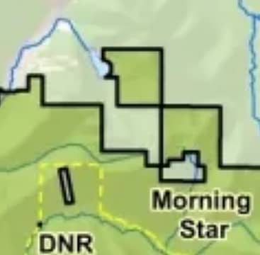 DNR Map 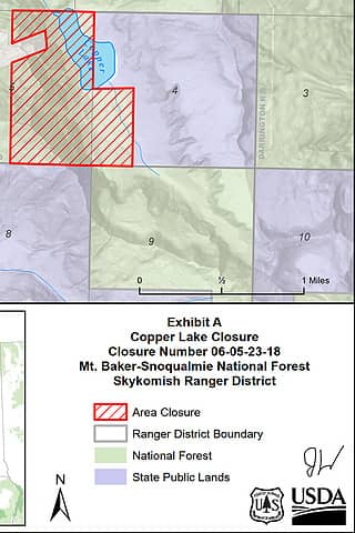 FS Map (Ranger District Boundary?)
|
| Back to top |
|
|
|
|
You cannot post new topics in this forum
You cannot reply to topics in this forum
You cannot edit your posts in this forum
You cannot delete your posts in this forum
You cannot vote in polls in this forum
|
Disclosure: As an Amazon Associate NWHikers.net earns from qualifying purchases when you use our link(s). |


