Forum Index > Trip Reports > Warrior Peak (attempt) 7 June 2014, ONP via ONF-Buckhorn
 Reply to topic
Previous :: Next Topic
Author Message
meck
Member
Member


Joined: 31 Dec 2010
Posts: 922 | TRs | Pics
meck
Member
PostSun Jun 08, 2014 10:22 am 
Warrior Peak attempt (ONP via ONF-Buckhorn), 7-June-2014: The weather looked good to go make an attempt at climbing Warrior Peak (Constance's northern neighbor), and after seeing a recent picture posted by Luc from Del Monte ridge, the snow conditions looked OK too. I arrived at the Big Quilcene TH at 0655 and was on the trail by 0700. Passed only a handful of campers on the way up (though Shelter Rock camp was nearly full though...) and was to Marmot Pass by 0905 (elev. 6000').
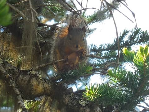
Chipmunk munching on a cone
Had to break out the crampons about 100 yards beyond the pass on the trail down to Boulder Shelter. The snow was compact and nearly impossible to kick steps into. There were at least three portions of the trail where more than 100 feet was covered with the compact snow/ice. This could possibly be avoided by going off trail south and above Marmot Pass and heading west directly down the further south ridge line bounding Boulder Shelter on the north...
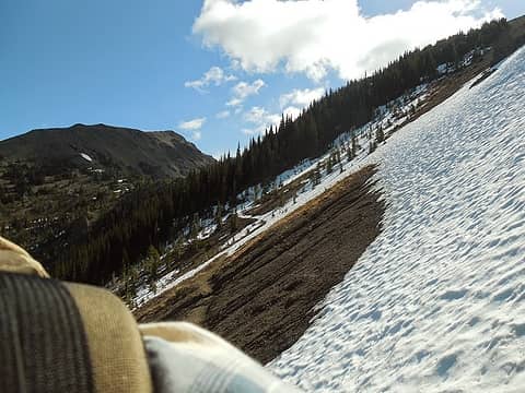
Looking back toward Marmot Pass, very hard snow across the trail (crampons required)
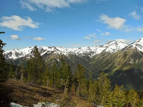
View south west towards Del Monte Ridge and Mt Mystery across the Dungeness
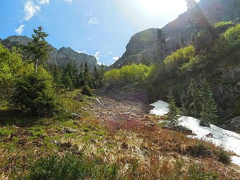
Arrived at Boulder Shelter (which is completely melted out) at ~1005 and headed south towards Home Lake. On a side note, the slope up to Charlia Pass appeared to still have some snow on it,though patchy, and the trail to Home Lake, where it runs below Inner Constance is still covered in snow. I reached the "left turn" to head up to Warrior Peak at 1050 (elev ~4700'). I was able to find the location that appeared to minimize bushwhacking, it basically hugged the northern edge of Inner Constance (my GPS said it was 10T UTM 0488918, 5292057). I was able to head up a rock gully and then onto remaining snow patches for much of the ascent (only needed trekking poles on this snow). The higher you go the more you are funneled into gully which exits the upper Constance-Warrior cirque, I reached it by 1200. The cirque is still full of snow, but its large and looked like a nice place to hang-out. I heard a couple of what sounded like smaller rocks, cut loose somewhere around the cirque. I saw tracks that indicated someone else had been here in the last week or so, and in addition to climbing Warrior, they had also wandered around here quite a bit.
First look uphill
First look uphill
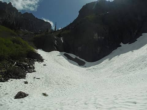
First snow slope just up hill
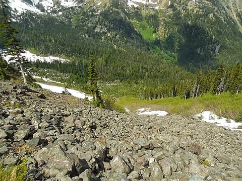
Looking back down the first rock and snow slope
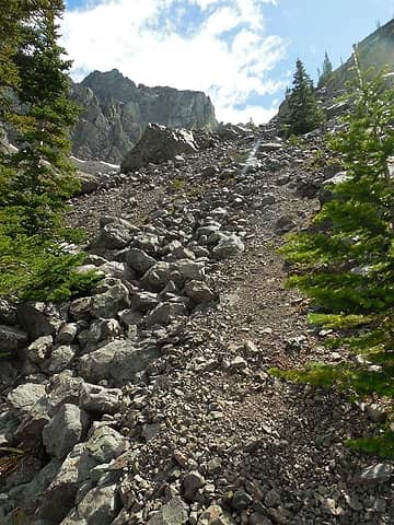
Sort of a way trail up some boulder patches
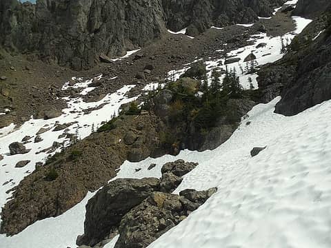
Across this snow patch past the trees on the upper right into the gully
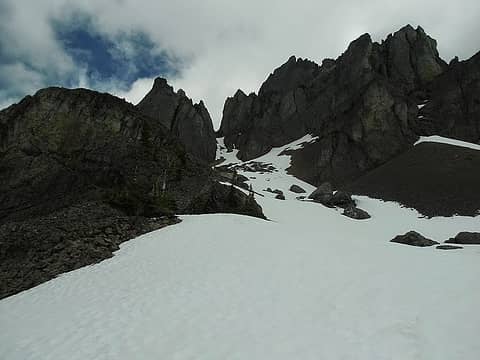
Finally looking up at the coulior from inside the upper Inner Constance-Warrior cirque/bowl
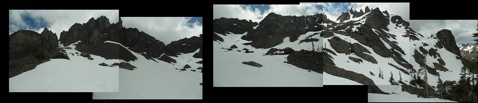
Pseudo Pano of the upper cirque
I was very thankful that the previous climber had been here. The couloir that runs up between the north and south summits (a giant ramp) was very imposing to me. From what I could see it looked like the slope up exceeded 45 degrees in angle, was still filled with about 2-3 feet of snow, and the run out if you slipped could involve some very uncomfortable encounters with large boulders and rock patches. However the previous climber had made a very nice looking zig-zag track up. So without further ado, I made the climb up to the base of the couloir, donned climbing helmet (which I should have put on earlier), put on the crampons, stowed the trekking poles, and broke out the ice-axe. I'm a bit of a novice with the ice-axe and crampon climbing (take that as you want regarding my judgement...) so this slope was a pretty good test as far as moving with that gear. The snow seemed solid (no obvious loose slabs on top of more compact stuff etc.), and turned out to be only maybe two feet thick. It was still compact enough that I would NOT attempt this without both crampons and ice-axe as you would not have time to stop on this steep slope or dig-in if you were to slip.
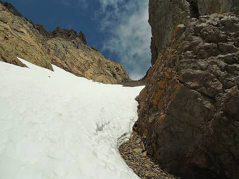
About halfway up the coulior
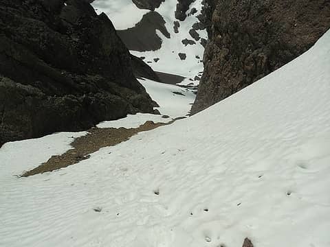
looking back down the coulior into the cirque
The coulior, I think, did reach about 50 degrees slope for about 200'and then evened out a bit to 45 degrees nearer the top. The last 80' of the couloir have melted out, so I pulled the crampons off while precariously trying not to slide down the needle shale "hell" and then headed up to the top (~7000' elevation), arriving at 1320,... and this is where I became very disappointed. Although it has been blue-sky above the peak all morning, by the time I arrived, low clouds had piled up against the east side of Warrior Peak, and it appeared Constance too. This had dropped the visibility to no more than about 30 feet to the east (and the summit was completely enveloped), although it was still clear looking south-west towards Home Lake/Del Monte Ridge. My intent was to climb the SE summit. From previous TRs I'd read in preparation it sounded like there was a ledge/shelf that you had to climb onto (via a 4th class move or 3rd class if you went slightly further east), but I could not see it at all and visibility dropped to about 15 feet when I walked on the east side snow patch (which was surprisingly soft given its orientation) into the cloud near where the ledge should be. I contemplated trying my luck on the NW peak (as it was still clear at that moment), but I'd not read the descriptions on how to best scramble up it (though the pillow basalt blocks did appear to provide some cracks/gullies that were climbable). So here I was stuck, about 300' short of either summit (no point in risking it, solo, if I'm not going to see anything anyways).
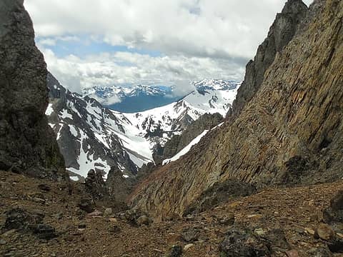
Clear and beautiful to the SW looking at Del Monte Ridge
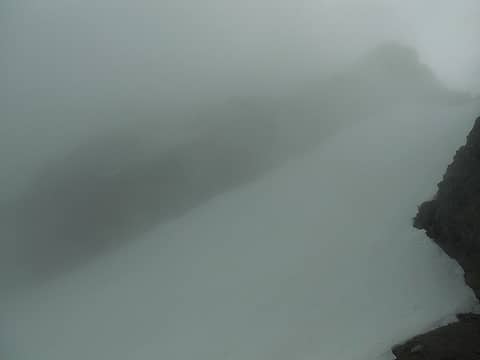
The fog only got thicker a few minutes later looking SE
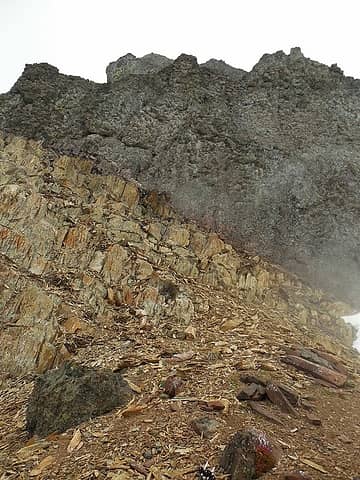
The NW Summit, the route is up the left angling light brown shale ramp then up through the pillow basalt
I decided to wait an hour to see if conditions would clear up a bit, they did not. I ate lunch, took pictures of what was visible (including the little plastic warrior tied to a rock sitting on a bigger rock), hit my turn-around time and at 1430 began the down climb, with the clouds now fully enclosing both sides of the peak.
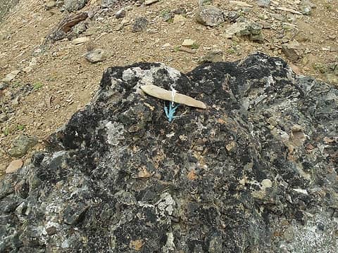
Plastic Warrior standing (or rather laying down on) watch
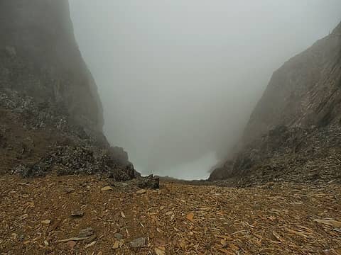
Looking back down the coulior when preparing to leave
Although I did not particularly enjoy climbing backwards down the coulior on the snow (more tiring than I'd anticipated), it seemed infinitely better than having to deal with the shale mess it sounds like during dry conditions! I was back to the upper cirque by 1530. By this time the low clouds (which bottomed out right around 6800') had obscured the top of Inner Constance too, and some of the higher ridges across the Dungeness drainage.
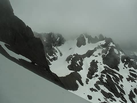
Obscured Inner Constance across the cirque
The trip from the base of the coulior, into the upper cirque back and back to the trail was downright enjoyable, boot skiing for hundreds of feet on the descent! I was back on the trail by 1630 and headed north. Came across many more backpackers on the way out than the way in. Passed by Boulder Shelter at 1720, was able to boot across the, now much softer, snow patches up to Marmot Pass, arriving there at 1830. I had dinner, watched some skiers make swinging curves down through the upper bowl south of the pass, and enjoyed the beautiful view to the west; a mixture of green forest, alpine brown, low clouds covering the upper edges of the ridges, and then the blue sky and high clouds highlighted in the orange of the evening sun. What a fantastic place to live!
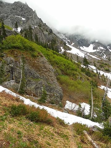
Back on the trail (looking south w/ Inner Constance mass on the upper left)
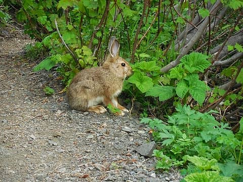
Rabbit, not particularly phased by my presence chilling out on the trail down
Passed lots of overnight backpackers on the way down (Camp Mystery was nearly full given that snow still covered many sites) and arrived at the car by 2030. Round Trip mileage somewhere around 19-20 miles, elevation gain ~6800-6900'. It was a nice trip, will have to do it again when the weather is more likely to cooperate. [edit minor updates to add elevations and fix readability]

*Just say NO to Rent-Seeking, don't give up the concept of "ownership"*
Back to top Reply to topic Reply with quote Send private message
ranger rock
One of the boys


Joined: 14 Dec 2011
Posts: 2550 | TRs | Pics
ranger rock
One of the boys
PostSun Jun 08, 2014 10:31 am 
That sounds like quite an adventure. Did you take any pictures?

Back to top Reply to topic Reply with quote Send private message
Magellan
Brutally Handsome


Joined: 26 Jul 2006
Posts: 13116 | TRs | Pics
Location: Inexorable descent
Magellan
Brutally Handsome
PostSun Jun 08, 2014 10:36 am 
Very cool sounding trip. up.gif Hopefully you can post some of your pictures.

Back to top Reply to topic Reply with quote Send private message
meck
Member
Member


Joined: 31 Dec 2010
Posts: 922 | TRs | Pics
meck
Member
PostSun Jun 08, 2014 10:39 am 
I've got lots of pictures, but not sure where to post them since ImageShack is no longer an option and Flikr requires new account confirmation via a cell phone text message (I don't have a cell phone...)

*Just say NO to Rent-Seeking, don't give up the concept of "ownership"*
Back to top Reply to topic Reply with quote Send private message
reststep
Member
Member


Joined: 17 Dec 2001
Posts: 4759 | TRs | Pics
reststep
Member
PostSun Jun 08, 2014 11:34 am 
Thanks for the report. That is a long day hike. I hope you are able to post some pictures.

"The mountains are calling and I must go." - John Muir
Back to top Reply to topic Reply with quote Send private message
Abert
Member
Member


Joined: 02 Sep 2010
Posts: 588 | TRs | Pics
Location: Sequim
Abert
Member
PostSun Jun 08, 2014 11:52 am 
Too bad the weather messed with you after all that effort. But it certainly does provide the impetus for another trip. Living in Sequim for the last year and having a close daily view of mountains for the first time I've been amazed to see how regularly Gray Wolf and Deer Ridges disappear in the clouds by midday after clear mornings. For posting photos, Picasa offers a free GB of storage. It requires a Google account but the signup page says a cellphone # is optional.

Back to top Reply to topic Reply with quote Send private message
meck
Member
Member


Joined: 31 Dec 2010
Posts: 922 | TRs | Pics
meck
Member
PostTue Jun 10, 2014 9:04 pm 
Pictures added, hope everyone can see these. Thanks for recommending picasa Abert! (I did not feel too violated by Google's terms of service, though I don't like the whole recording of your computer hardware's UIDs... that's crossing the line a bit much, but I guess that's the price for free..)

*Just say NO to Rent-Seeking, don't give up the concept of "ownership"*
Back to top Reply to topic Reply with quote Send private message
Magellan
Brutally Handsome


Joined: 26 Jul 2006
Posts: 13116 | TRs | Pics
Location: Inexorable descent
Magellan
Brutally Handsome
PostTue Jun 10, 2014 9:32 pm 
Nice add. up.gif

Back to top Reply to topic Reply with quote Send private message
rambln
Member
Member


Joined: 28 May 2013
Posts: 37 | TRs | Pics
Location: Kitsap
rambln
Member
PostTue Jun 10, 2014 9:47 pm 
Awesome! Thanks for the pics. Warrior is high on my list of to-do's.

Back to top Reply to topic Reply with quote Send private message
   All times are GMT - 8 Hours
 Reply to topic
Forum Index > Trip Reports > Warrior Peak (attempt) 7 June 2014, ONP via ONF-Buckhorn
  Happy Birthday EastKing, tuck and roll!
Jump to:   
Search this topic:

You cannot post new topics in this forum
You cannot reply to topics in this forum
You cannot edit your posts in this forum
You cannot delete your posts in this forum
You cannot vote in polls in this forum