| Previous :: Next Topic |
| Author |
Message |
realityguy
Member


Joined: 11 Apr 2010
Posts: 373 | TRs | Pics
Location: 95% Lynnwood,5% Joyce..wish it was the other way around! |
New camera..not happy with the photos  ..posted this more for the info for people that need it...
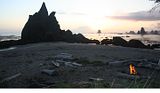
Third beach section on the ONP.. It went well. We hit the trailhead at Oil City at just before 7am.The trail is easy following the bank of the river to the ocean with an area of pretty flat rocks near the end that go around a large driftwood pile and down onto hard sandy beaches below. ..posted this more for the info for people that need it...
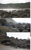
Third beach section on the ONP.. It went well. We hit the trailhead at Oil City at just before 7am.The trail is easy following the bank of the river to the ocean with an area of pretty flat rocks near the end that go around a large driftwood pile and down onto hard sandy beaches below. 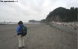 We hiked in the first two miles and around the head with all the boulder hopping, hitting that at roughly the .6 low tide we had...across the next cove(Jefferson?) and up the rope ladders onto Hoh Head. We hiked in the first two miles and around the head with all the boulder hopping, hitting that at roughly the .6 low tide we had...across the next cove(Jefferson?) and up the rope ladders onto Hoh Head.
 HH seemed an endless and meandering trail through a forest of large trees but well marked; with lots of ups and downs through ravines and back into the woods again.. lots of salal berries for eating. There are a few peek-a-boo beach spots along the trail, but too high, steep, and rugged to get access to them. We were trying to get to Mosquito Creek in somewhat of a hurry to cross the "terrible sounding"(on the net) deep river.
 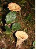 Yes we did find a couple edible white chantrelles besides the wooley ones,didn't pick them..
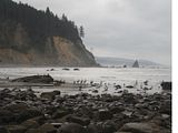
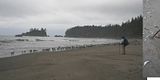
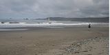
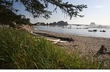
Mosquito Creek and beach.. turned out to be ankle deep crossing with some small sticks across it to not even get your shoes wet. Unfortunately anywhere on the net doesn't tell you squat about that crossing.. which sucks. This time of year it's pretty much a high and dry crossing up to about a 6' tide(I figure).it would have been nice to know that. It has a nice beach..somewhat like Shi-shi but without POTA with fewer seastacks. Lots of gulls were scarfing up herring flopping on the sand on the northern end of the beach, washing in with the tide. They would have provided an easy meal just picking up live ones if you are into eating them. The beach is about two miles of wide hard sand without gravel for swimming or walking. The main campground is huge with smaller ones along the trail to the beach. The main one sits high above the beach about 30' with a 100 yard walk down to the creekside, across a logjam to get to the beach or creek for water. There was only one couple camping on the beach in that area, next to the mouth of the creek.
Yes we did find a couple edible white chantrelles besides the wooley ones,didn't pick them..
Mosquito Creek and beach.. turned out to be ankle deep crossing with some small sticks across it to not even get your shoes wet. Unfortunately anywhere on the net doesn't tell you squat about that crossing.. which sucks. This time of year it's pretty much a high and dry crossing up to about a 6' tide(I figure).it would have been nice to know that. It has a nice beach..somewhat like Shi-shi but without POTA with fewer seastacks. Lots of gulls were scarfing up herring flopping on the sand on the northern end of the beach, washing in with the tide. They would have provided an easy meal just picking up live ones if you are into eating them. The beach is about two miles of wide hard sand without gravel for swimming or walking. The main campground is huge with smaller ones along the trail to the beach. The main one sits high above the beach about 30' with a 100 yard walk down to the creekside, across a logjam to get to the beach or creek for water. There was only one couple camping on the beach in that area, next to the mouth of the creek.
 After passing a seastack similar but smaller than Strawberry Point with a small sandy path out to it,you come up to a seastack by shore with a small tunnel going through it where you can time the tide and make it through between waves without getting wet(probably 2.0 tide) that goes to a more gravelly smaller cove. However, we found out later that the overland trail marking was not just for getting over that seastack but the correct one for getting on top of the next headlands so had to backtrack back through the tunnel with a slightly wetter trip.
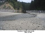
Goodman Falls Creek headlands...At the beginning(south to north)a small slide has decimated the trail but there is a footpath across that area that eventually goes into the woods.From there it is an easy trail that eventually crosses a small area of the upper streambed that is dry this time of year. The trail turns down and follows the far bank of Goodman Creek. CAUTION:There is a point where it appears the trail goes down to the creekside or over a large log. DO NOT CLIMB OVER THAT LARGE LOG! We did as it appeared several others had done the same thing by all the footprints in the area of a lot of hikers lost wandering around the hard rocks and sand of the creekbed trying to pick up the trail again once it disappears. After about a half hour, we retracked our trail to before that log across the trail and I noticed the last small trail down to the creekside has a red buoy tide to a log on the other side and some unnatural stones under water where it appeared someone had started a bridge across but gsve up.I took off my boots and waded across..sure enough a good trail appeared on the other side.The wife did likewise and joined me on the trail on the far side following the northern bank of Goodman Creek downstream.A couple hundred yards downstream,the trail drops down over a tree root and places you alongside the stream again..We again walked straight following the streambed but again it was the wrong direction.There is a small orange tag about the size of a business card attached to the end of a log overhead.This is where you are supposed to cross the stream again(12" deep) to get to the other side for the trail.We ended up close to the falls(a trickle),walking a cross a gravel bar, over a log and 2' stream, and bushwhacked up the bank following someone else's "path" to the top, which rejoined the trail and started heading north again.
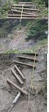
The trail went by some huge cedars and eventually we could see the end of the headlands and preparing for the rope ladders going back down to the beach.The ladders are in sad shape with a cable broken near the top and it appeared only a small rope was holding one side together..but at an angle on the steps forcing your foot alongside the cables on that side. Near the bottom, the last 3-4' the steps are broken out and it's basically just using the rope for the lower portion. I had to do those three times to get my gear down, go back up and help the wife down, then go up and get her pack. Some serious repair is needed to make them safe again.
After passing a seastack similar but smaller than Strawberry Point with a small sandy path out to it,you come up to a seastack by shore with a small tunnel going through it where you can time the tide and make it through between waves without getting wet(probably 2.0 tide) that goes to a more gravelly smaller cove. However, we found out later that the overland trail marking was not just for getting over that seastack but the correct one for getting on top of the next headlands so had to backtrack back through the tunnel with a slightly wetter trip.
Goodman Falls Creek headlands...At the beginning(south to north)a small slide has decimated the trail but there is a footpath across that area that eventually goes into the woods.From there it is an easy trail that eventually crosses a small area of the upper streambed that is dry this time of year. The trail turns down and follows the far bank of Goodman Creek. CAUTION:There is a point where it appears the trail goes down to the creekside or over a large log. DO NOT CLIMB OVER THAT LARGE LOG! We did as it appeared several others had done the same thing by all the footprints in the area of a lot of hikers lost wandering around the hard rocks and sand of the creekbed trying to pick up the trail again once it disappears. After about a half hour, we retracked our trail to before that log across the trail and I noticed the last small trail down to the creekside has a red buoy tide to a log on the other side and some unnatural stones under water where it appeared someone had started a bridge across but gsve up.I took off my boots and waded across..sure enough a good trail appeared on the other side.The wife did likewise and joined me on the trail on the far side following the northern bank of Goodman Creek downstream.A couple hundred yards downstream,the trail drops down over a tree root and places you alongside the stream again..We again walked straight following the streambed but again it was the wrong direction.There is a small orange tag about the size of a business card attached to the end of a log overhead.This is where you are supposed to cross the stream again(12" deep) to get to the other side for the trail.We ended up close to the falls(a trickle),walking a cross a gravel bar, over a log and 2' stream, and bushwhacked up the bank following someone else's "path" to the top, which rejoined the trail and started heading north again.
The trail went by some huge cedars and eventually we could see the end of the headlands and preparing for the rope ladders going back down to the beach.The ladders are in sad shape with a cable broken near the top and it appeared only a small rope was holding one side together..but at an angle on the steps forcing your foot alongside the cables on that side. Near the bottom, the last 3-4' the steps are broken out and it's basically just using the rope for the lower portion. I had to do those three times to get my gear down, go back up and help the wife down, then go up and get her pack. Some serious repair is needed to make them safe again.
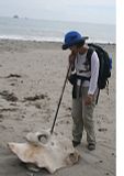 Yeah..I couldnt talk the wife into carrying that whale bone home for me..LOL!How does something that probably weighs 50+ lbs wash up on a beach?
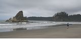
Toleak..We rolled into Toleak Point about 4:30PM which had three small tents on the southern beaches, well spaced apart.We stopped to pump some cooking water well up the creek,looks pretty slimy in portions below. Then we headed up to the northern portion to our favorite site..finding not a sole on the north side of the point! We set up camp, changed into shorts and beach shoes, wandered around the area just enjoying the solitude, sunshine, and beach with an outgoing tide(about .1 at sunset).There were a lot of cranes(not herons) and seals on the outer rocks south of the point and the rocks south of Strawberry Point to the north.
Yeah..I couldnt talk the wife into carrying that whale bone home for me..LOL!How does something that probably weighs 50+ lbs wash up on a beach?
Toleak..We rolled into Toleak Point about 4:30PM which had three small tents on the southern beaches, well spaced apart.We stopped to pump some cooking water well up the creek,looks pretty slimy in portions below. Then we headed up to the northern portion to our favorite site..finding not a sole on the north side of the point! We set up camp, changed into shorts and beach shoes, wandered around the area just enjoying the solitude, sunshine, and beach with an outgoing tide(about .1 at sunset).There were a lot of cranes(not herons) and seals on the outer rocks south of the point and the rocks south of Strawberry Point to the north. 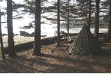
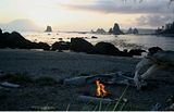 Dinner was cooked during sunset with a nice beach fire started for the evening.
About midnight the pouring rain came down with heavy droplets on the tent.I discovered a few leaks in the seams I had missed sealing my homemade tipi but I just pulled out a hammock tarp I had brought along and put it over us inside the tent, went back to sleep.The next morning the area was pretty much saturated..more so than I thought which we discovered on the way out.We ate a leisurely breakfast, packed up and headed north behind 3 of the 5 of the campers from the southern side of the point. Dinner was cooked during sunset with a nice beach fire started for the evening.
About midnight the pouring rain came down with heavy droplets on the tent.I discovered a few leaks in the seams I had missed sealing my homemade tipi but I just pulled out a hammock tarp I had brought along and put it over us inside the tent, went back to sleep.The next morning the area was pretty much saturated..more so than I thought which we discovered on the way out.We ate a leisurely breakfast, packed up and headed north behind 3 of the 5 of the campers from the southern side of the point.
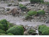
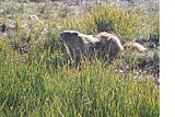
 Just before Scott's Creek we saw a drenched female raccoon with her two babbies out on the beach rocks looking for breakfast...snapped a couple pictures.The mother headed for the rocks,leaving the babies to fend for themselves.I tried to coax them to follow mom but they wouldn't budge.There was no one heading out behind us,so we figured they'd eventually catch up with her.
Scott's Creek...was overloaded with campers at what I consider one of the worst beach camps of the area with rocky beaches, camp faces north, and crowded, uncomfortable campsites.Don't these people realize paradise is around the corner? With a tide at almost zero at sunset the evening before and the water looking like a calm lake, why didn't they continue south???.. Everyone looked like a bunch of drowned rats with the driftwood piles sporting soggy down mummy bags and upside down tents from people trying to dry out in the morning sun. There were even 3-4 tents in the middle of the cove between Taylor Head and Scott's Bluff.. in the only spot that possibly could have been dry and above the tide. They had a couple scouts out searching for firewood on a pretty bare beach for that.
Scott's Bluff...Yep. The steps are gone.. another slide within the last month or so has taken out the steps and a new path up the cliff has been created with mud/clay steps dug into the bank until another slide changes things again. We made it down without incident but the three other hikers alongside us were wearing sandals which they removed in the cove and washed off the slimy clay when they hit the bottom.
Taylor Head.. Steps going up the southside are still there.. think someone somewhere had counted 90 of them. There were a few more tents huddled under the trees at the campsite at the top with a tarp hung above what must have been their cooking/seating area. We headed across the headland for the final rope ladders down to the final beach strip.. no problems there. We crossed the beach and stopped to finish off our water, have a couple energy bars, then headed out to the car.
On the way back to Oil City to get the other car we stopped at Sully's for one of their double burgers, coke, and fries combo($6).. nothing special but still always a nice change after trail food for a couple days.
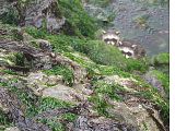
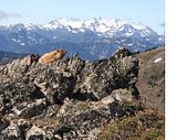
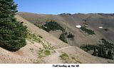
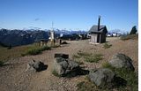
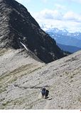
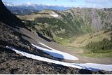
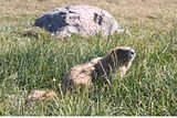
After picking up the wife's car at Oil City, we drove to our house at Whiskey Creek (Joyce), had a large dinner and watched a crappy movie on "Victoria TV"(one station),hot showers, and bedded down for the night in comfort. The next day we spent "ridge hiking" an 8 mile round trip from Obstruction Point to about halfway to Deer Park for a change of scenery and checking out the marmots on the" zamboni groomed trails" of the upper ONP with 100 other people.. quite an extreme change from the solitude of the previous days. .but it was a nice scenic day hike of the upper ONP on a gorgeous sunny day !
Just before Scott's Creek we saw a drenched female raccoon with her two babbies out on the beach rocks looking for breakfast...snapped a couple pictures.The mother headed for the rocks,leaving the babies to fend for themselves.I tried to coax them to follow mom but they wouldn't budge.There was no one heading out behind us,so we figured they'd eventually catch up with her.
Scott's Creek...was overloaded with campers at what I consider one of the worst beach camps of the area with rocky beaches, camp faces north, and crowded, uncomfortable campsites.Don't these people realize paradise is around the corner? With a tide at almost zero at sunset the evening before and the water looking like a calm lake, why didn't they continue south???.. Everyone looked like a bunch of drowned rats with the driftwood piles sporting soggy down mummy bags and upside down tents from people trying to dry out in the morning sun. There were even 3-4 tents in the middle of the cove between Taylor Head and Scott's Bluff.. in the only spot that possibly could have been dry and above the tide. They had a couple scouts out searching for firewood on a pretty bare beach for that.
Scott's Bluff...Yep. The steps are gone.. another slide within the last month or so has taken out the steps and a new path up the cliff has been created with mud/clay steps dug into the bank until another slide changes things again. We made it down without incident but the three other hikers alongside us were wearing sandals which they removed in the cove and washed off the slimy clay when they hit the bottom.
Taylor Head.. Steps going up the southside are still there.. think someone somewhere had counted 90 of them. There were a few more tents huddled under the trees at the campsite at the top with a tarp hung above what must have been their cooking/seating area. We headed across the headland for the final rope ladders down to the final beach strip.. no problems there. We crossed the beach and stopped to finish off our water, have a couple energy bars, then headed out to the car.
On the way back to Oil City to get the other car we stopped at Sully's for one of their double burgers, coke, and fries combo($6).. nothing special but still always a nice change after trail food for a couple days.
After picking up the wife's car at Oil City, we drove to our house at Whiskey Creek (Joyce), had a large dinner and watched a crappy movie on "Victoria TV"(one station),hot showers, and bedded down for the night in comfort. The next day we spent "ridge hiking" an 8 mile round trip from Obstruction Point to about halfway to Deer Park for a change of scenery and checking out the marmots on the" zamboni groomed trails" of the upper ONP with 100 other people.. quite an extreme change from the solitude of the previous days. .but it was a nice scenic day hike of the upper ONP on a gorgeous sunny day !
|
| Back to top |
  
|
|
Phil
Member

Joined: 02 Jul 2003
Posts: 2025 | TRs | Pics
Location: Shoreline, WA |
|
Phil
Member
|
 Tue Aug 31, 2010 9:25 pm |
|
|
Lots of good info in that report, thanks! I thought the pics were good, too.
|
| Back to top |
|
|
omega
Member
Joined: 01 Sep 2005
Posts: 41 | TRs | Pics
|
|
omega
Member
|
Mon Sep 13, 2010 1:56 am |
|
|
Yes - nice report. I and some friend just did the same hike over Labor Day weekend. I also did it back in 2005 ( Oil City Third Beach TR 2005 ). I really like that stretch.
The cable ladder on the north side of Goodman Creek head has been fixed - or at least it was all one piece when I was there. That could just mean that the broken part has been removed though.
I agree that the Scott Creek camping area is the pits. Too many people and not very esthetic. There are good camping spots along the beach in both directions from there.
|
| Back to top |
|
|
Spotly
Member

Joined: 06 Jan 2004
Posts: 3723 | TRs | Pics
Location: Spokane Valley |
|
Spotly
Member
|
Mon Sep 13, 2010 6:51 am |
|
|
We're looking at this as a possible winter hike. Any idea how that crossing would be that time of year? Our guide good calls it a Spring, Summer and Fall hike. Not sure why Winter is excluded and I'm not familiar enough with coastal weather and river antics to be totally comfy just doing it.
Nice TR. Sorry you're not happy with the pics. Sure it wasn't just the lighting? My camera throws some real sucky ones out when the lighting is just right.
|
| Back to top |
|
|
realityguy
Member
Joined: 11 Apr 2010
Posts: 373 | TRs | Pics
Location: 95% Lynnwood,5% Joyce..wish it was the other way around! |
Omega..I was going to contact the park about the ladders,got sidetracked..maybe someone there read my posts.They were in sad shape,glad to hear they are fixed.
Scott's Creek..baffles me why people would stop there when the better beaches are around the corner...???..Maybe those people arrived really late(but it would have been low tide beach walking),haven't ever been beyond, or they like the seastacks there.It may have been raining the 1-1/2 miles up the beach from Toleak..while we had a nice sunset!..  I don't know.
As far as the rivers..I've never been there in winter.More than likely it would be a different story as far as crossing them.
Mosquito Creek has quite a deep pool that shallows out to nothing now at the beach end.I imagine during the winter at low tide it might have some flow but probably knee deep or the flow cuts a deeper channel..but I'm not sure.Because it is a typical coastal stream,it's more just a large pool that probably flows well after heavy storms.I would try to pick a lowest tide when it's been dry for a week or two to eliminate a lot of the flow.Keep in mind that a low tide is needed at the first boulder point,then 3-1/2miles of woods to hit the second "tide sensitive spot".I had problems finding anything on the web about that so not knowing what Mosquito creek was going to be like,I pushed on through at a faster pace than I would have liked..had I know MC was going to be nothing.That's the main reason I posted this trip report because of the unknown factors in that section.
I don't know.
As far as the rivers..I've never been there in winter.More than likely it would be a different story as far as crossing them.
Mosquito Creek has quite a deep pool that shallows out to nothing now at the beach end.I imagine during the winter at low tide it might have some flow but probably knee deep or the flow cuts a deeper channel..but I'm not sure.Because it is a typical coastal stream,it's more just a large pool that probably flows well after heavy storms.I would try to pick a lowest tide when it's been dry for a week or two to eliminate a lot of the flow.Keep in mind that a low tide is needed at the first boulder point,then 3-1/2miles of woods to hit the second "tide sensitive spot".I had problems finding anything on the web about that so not knowing what Mosquito creek was going to be like,I pushed on through at a faster pace than I would have liked..had I know MC was going to be nothing.That's the main reason I posted this trip report because of the unknown factors in that section.  Goodman has to be crossed at the top smaller tributary under the brush which appears to get about knee deep by the marks on the banks and about an 8-10' wide crossing(dry now)..then the river (30' now.maybe 40-45' at high but shallow there,gravel bar south side)needs fording below.That could be a lot deeper in winter,maybe thighs but not a lot of flow then I assume.Then I think the next crossing is Falls Creek(30') below the falls.I imagine that might be knee deep slow water or so from what the steep banks look like.
Hiking in from the lower end..the Hoh might be flowing pretty good but the trail in is more of a fisherman's type trail so it must be okay and above the river during the winter except for the most extreme times.The first beach you get to at the mouth has flat gravel,then outside the mouth hard sand unless it's high tide,then it would be logwalking over the pile there(If it is high tide,you couldn't make the next point anyway)..then the boulder hopping at the point for 100 yards or so.Next cove shouldn't be a problem at lower tides and about 15minutes to cross on sand.Rope ladders up Hoh Head would be muddy as would be the trails across it.North end of Hoh Head..goes to the campground ,then goes down to a logjam on the south end of Mosquito Creek..to the beach there..easy trail down.Then beach walking for a couple miles.
The next headland trailmarker point is doing some sluffing-off ..and that will probably be some "making your own trail" north or following someone else's footsteps across the slide area for 100'..depending on who's been there before...then back to a decent trail in the woods.
The North end problems.. might be a "shoes-off" crossing at Scott's Creek and whatever the clay/gravel bank throws at you at the north end of Scott's Head.That might be a real problem in winter,especially this one.It's sluffing off badly and has changed EVERY time(5) I've been in there the last year or two.The last couple trips were a month apart and that had even changed as far as a different route,more big trees over the bank, and new steps cut/kicked into the mud bank at a different location.Hopefully that'll settle out soon and stabilize for a more permanent trail up the bank,but doesn't appear to be doing so.This winter might have some serious changes there.
If I go in that section again..I'll probably only go in one end and as far as Toleak(from the north down) or Mosquito Creek(from the south up).The car-shuttle hassles for me were just not worth the headaches of having two of them there.A person can camp at either campground and dayhike the center section in between.
In late summer the falls aren't flowing,and Goodman looks like a mosquito pond..no reason to do that section again..however..just above the falls on the north end there were a few outstanding big cedar trees.
Goodman has to be crossed at the top smaller tributary under the brush which appears to get about knee deep by the marks on the banks and about an 8-10' wide crossing(dry now)..then the river (30' now.maybe 40-45' at high but shallow there,gravel bar south side)needs fording below.That could be a lot deeper in winter,maybe thighs but not a lot of flow then I assume.Then I think the next crossing is Falls Creek(30') below the falls.I imagine that might be knee deep slow water or so from what the steep banks look like.
Hiking in from the lower end..the Hoh might be flowing pretty good but the trail in is more of a fisherman's type trail so it must be okay and above the river during the winter except for the most extreme times.The first beach you get to at the mouth has flat gravel,then outside the mouth hard sand unless it's high tide,then it would be logwalking over the pile there(If it is high tide,you couldn't make the next point anyway)..then the boulder hopping at the point for 100 yards or so.Next cove shouldn't be a problem at lower tides and about 15minutes to cross on sand.Rope ladders up Hoh Head would be muddy as would be the trails across it.North end of Hoh Head..goes to the campground ,then goes down to a logjam on the south end of Mosquito Creek..to the beach there..easy trail down.Then beach walking for a couple miles.
The next headland trailmarker point is doing some sluffing-off ..and that will probably be some "making your own trail" north or following someone else's footsteps across the slide area for 100'..depending on who's been there before...then back to a decent trail in the woods.
The North end problems.. might be a "shoes-off" crossing at Scott's Creek and whatever the clay/gravel bank throws at you at the north end of Scott's Head.That might be a real problem in winter,especially this one.It's sluffing off badly and has changed EVERY time(5) I've been in there the last year or two.The last couple trips were a month apart and that had even changed as far as a different route,more big trees over the bank, and new steps cut/kicked into the mud bank at a different location.Hopefully that'll settle out soon and stabilize for a more permanent trail up the bank,but doesn't appear to be doing so.This winter might have some serious changes there.
If I go in that section again..I'll probably only go in one end and as far as Toleak(from the north down) or Mosquito Creek(from the south up).The car-shuttle hassles for me were just not worth the headaches of having two of them there.A person can camp at either campground and dayhike the center section in between.
In late summer the falls aren't flowing,and Goodman looks like a mosquito pond..no reason to do that section again..however..just above the falls on the north end there were a few outstanding big cedar trees.
|
| Back to top |
|
|
omega
Member
Joined: 01 Sep 2005
Posts: 41 | TRs | Pics
|
|
omega
Member
|
Mon Sep 13, 2010 10:20 am |
|
|
I've been interested in a winter hike on the coast too.
I think the issues are two:
In general the tides are higher because of storms and wind and that can make crossings more difficult.
Also, probably more important, when it rains the rivers rise and get fast. These rivers drain an area that gets 200+ inches of rain per year.
|
| Back to top |
|
|
Spotly
Member
Joined: 06 Jan 2004
Posts: 3723 | TRs | Pics
Location: Spokane Valley |
|
Spotly
Member
|
Mon Sep 13, 2010 10:40 am |
|
|
Excellent beta. I'll bookmark this for the trip. Regarding a shuttle, would it be an easy bike stash maybe..or would it be lots of up and down to get back to the car?
|
| Back to top |
|
|
half fast
member

Joined: 21 Mar 2010
Posts: 1392 | TRs | Pics
Location: Living the dream in my 5th Wheel |
It's all about the fun, oh and maybe the chocolate - half fast
|
| Back to top |
|
|
strider
Member

Joined: 24 Aug 2002
Posts: 464 | TRs | Pics
Location: Silverdale |
|
strider
Member
|
Mon Sep 13, 2010 3:10 pm |
|
|
Omega has it spot on - wind, rain, tides. Any two of 'em, if they are cranked up, can make Goodman impassable at the ford. Once, I had a zero tide, but lotsa rain plus lotsa wind resulted in an armpit deep ford experience that we probably should not have done. Sure was glad I had everything in the pack double wrapped in trash bags....
Mosquito is not as much of a challenge, but high rain volume plus wind stacking up the ocean can still put your pack belt underwater at low tide.
The ocean routinely rearranges all those logs as well (that's how they got there, after all). Spent four hours more than a couple times, sitting in sideways rain waiting for the ocean to give the beach back.
Oly beach trips in winter are not for the faint of heart. I keep going back tho ..... maybe I just like abuse.
Nice TR.
strider
I've never been lost, but I'm frequently uncertain where my destination might be in relation to where I am at the moment....
strider
I've never been lost, but I'm frequently uncertain where my destination might be in relation to where I am at the moment....
|
| Back to top |
|
|
realityguy
Member
Joined: 11 Apr 2010
Posts: 373 | TRs | Pics
Location: 95% Lynnwood,5% Joyce..wish it was the other way around! |
| Quote: | | xcellent beta. I'll bookmark this for the trip. Regarding a shuttle, would it be an easy bike stash maybe..or would it be lots of up and down to get back to the car? |
The beach section access points are quite a ways apart..the lower one about 40 miles with about 15 of that as dirt roads..the others are farther apart.
I still think the best idea is to hit both ends and day hike the middle if you want from camping at MC or Toleak...
The middle and upper sections are farther apart yet at the access points.I don't know how many miles you like to bike...
|
| Back to top |
|
|
omega
Member
Joined: 01 Sep 2005
Posts: 41 | TRs | Pics
|
|
omega
Member
|
Tue Sep 14, 2010 8:45 am |
|
|
Yes, the roads are passable but not very good for biking.
I personally don't like the idea of hiking the same stretch twice so soon (in and out) BUT you can arrange to hike it at different tide which really does change the character of the hike. Plus, for me, there's always way more on a beach hike than I can take in the first time through.
Also, maybe this is obvious to y'all but I am often forgetting: when crossing water be sure to unbuckle you pack. Don't want to trip face down with 35 ackward lbs on your back .
|
| Back to top |
|
|
|
|
You cannot post new topics in this forum
You cannot reply to topics in this forum
You cannot edit your posts in this forum
You cannot delete your posts in this forum
You cannot vote in polls in this forum
|
Disclosure: As an Amazon Associate NWHikers.net earns from qualifying purchases when you use our link(s). |


 Nice...
